|
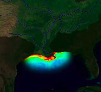
A visualization of the 'dead zone' in the northern Gulf of Mexico. (NOAA National Environmental Satellite, Data, and Information Service [NESDIS])
‘Dead Zone’ in the Gulf of Mexico forecast to be the second largest on record
 UNITED STATES
Thursday, June 13, 2019, 01:00 (GMT + 9)
A recent forecast of the size of the “Dead Zone” in the northern Gulf of Mexico for late July 2019 reports that it will cover 8,717-square-miles of the bottom of the continental shelf off Louisiana and Texas, reports the Louisiana State University (LSU).
What is hypoxia?
Hypoxia, or low oxygen, is an environmental phenomenon where the concentration of dissolved oxygen in the water column decreases to a level that can no longer support living aquatic organisms. Hypoxic areas, or “Dead Zones,” have increased in duration and frequency across our planet’s oceans since first being noted in the 1970s.
The largest hypoxic zone currently affecting the United States, and the second largest hypoxic zone worldwide, is the northern Gulf of Mexico adjacent to the Mississippi River.
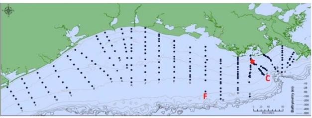
Location of hypoxia monitoring stations sampled in summer (not every year, depending on location of hypoxic area), the transects off Terrebonne Bay (transect C) and Atchafalaya Bay (transect F), and the ocean observing system (asterisk) off Terrebonne Bay. (Photo: courtesy gulfhypoxia.net)
The unusually high Mississippi River discharge in May controls the size of this zone, which will likely be the second largest zone since systematic measurements began in 1985. The water mass with oxygen concentrations less than 2 parts per million forms in bottom waters each year primarily as a result of nitrogen and phosphorus loading from the Mississippi River watershed, which fertilizes the Gulf of Mexico’s surface waters to create excessive amounts of algal biomass. The decomposition of this plant material in the bottom layer leads to oxygen loss.
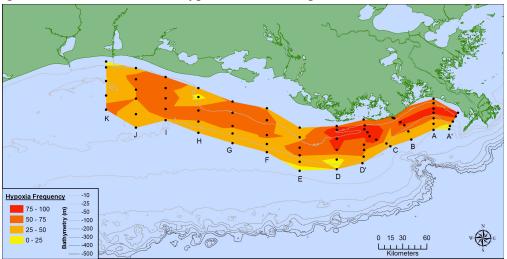
The frequency of mid-summer hypoxia (oxygen ≤ 2 mg l-1) over the 70 to 90 station grid on the Louisiana and Texas shelf during the summer from 1985 to 2014. The frequency is determined from those stations for which there are data for at least half of all cruises. From Rabalais et al. (2010). (Photo: courtesy gulfhypoxia.net)
The low oxygen conditions in the gulf's most productive waters stresses organisms and may even cause their death, threatening living resources, including fish, shrimp and crabs caught there. Low oxygen conditions started to appear 50 years ago when agricultural practices intensified in the Midwest. No reductions in the nitrate loading from the Mississippi River to the Gulf of Mexico have occurred in the last few decades.
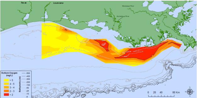
Oxygen concentrations in bottom water across the Louisiana shelf from July 23–July 30, 2018. Data source: N.N. Rabalais, Louisiana State University, Universities Marine Consortium, and R.E. Turner, LSU; funded by NOAA, National Centers for Coastal Ocean Science. (Photo: courtesy gulfhypoxia.net)
The predicted hypoxic area is about the size of the land area of New Hampshire and about 4.5 times the size of the Hypoxia Action Plan goal. This estimate assumes that there are no significant tropical storms in the two weeks before the monitoring cruise or during the cruise.
The estimate is made each year by LSU scientists Eugene Turner and Nancy Rabalais.
The report is posted here.
editorial@seafood.media
www.seafood.media
|


 Print
Print