|
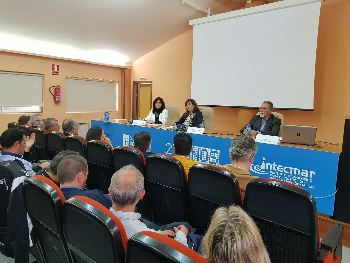
General Director of Fishery Development of Galicia, Susana Rodríguez, during Percegurú application presentation. (Photo: Xunta de Galicia)
Improvements in web tool will allow Galician barnacle harvesters to work more safely
 SPAIN
SPAIN
Tuesday, October 23, 2018, 21:10 (GMT + 9)
The Undersecretariat of Marine Affairs of Xunta de Galicia has just updated the web application "Percegurú" so that Galician barnacle harvesters can have sea conditions in each zone in which the resource is caught at any time of the day and can develop their activity with maximum security.
This was explained by Director General of Fisheries Development Susana Rodríguez in the presentation of the update of this tool, held at the Technological Institute for the Control of the Marine Environment (INTECMAR). INTECMAR director Covadonga Salgado also participated in the event.
This update responds to a generalized demand of the barnacle workers’ sector, raised through the fishermen’s association of Camariñas.
.png)
Webpage PERCEGURU | Source: mapas.intecmar.gal/perceguru/
In this line, Susana Rodríguez said that it is an example of the importance and the need to listen to the sector, know their concerns and work hand in hand to solve them.
The director recalled that this application has existed since 2012 and now what is done is to update it, improving its resolution, extending the risk degrees -- there were three and one more was added -- and contributing for the information contained in the web tool to update automatically, without interruption on the weekend.
In this sense, Susana Rodríguez stressed that Percegurú application provides basic information on the oceanographic and atmospheric conditions of each of the barnacle harvesting areas three days in advance and, therefore, allows the barnacle collectors (percebeiros) to guide their work . Thus, the director explained that fishermen can know information about the waves and, therefore, can fish safely and in a better organized manner.
With that advance, any barnacle collector can know in a simple way the local schedule of the tides; what the ambient temperature will be as well as the water with which it will be found; with what intensity and in what direction the winds are going to blow; what the strength and state of the sea is; and the direction, frequency and height of the waves.
Precisely, the height reached by the waves will be the determining factor to reflect on a map the degree of risk that the activity in each area can represent, showing it with a blue light or traffic light if the waves do not exceed one metre in height; green if the waves are between one and two metres; yellow if they are between two and three metres; and red when they exceed three metres.
This web tool was developed within the framework of the European RAIA Project, by the Oceanographic Modelling and Documentation and INTECMAR Scientific Support units, and uses Meteogalicia data.
editorial@seafood.media
www.seafood.media
|

 Print
Print