|
The SeaStar spacecraft orbiting the Earth (Credit: NASA/Goddard Space Flight Center, The SeaWiFS Project and GeoEye)
COMPANY OF THE WEEK: New Capabilities with OrbMap 7.5 from GeoEye
 (UNITED STATES, 9/23/2011)
GeoEye’s (Public, NASDAQ:GEOY) upcoming fourth quarter software release will soon be available and incorporates more capabilities and tools to help find fish faster.
In addition to the current features, OrbMap 7.5 is designed to provide captains with:
-
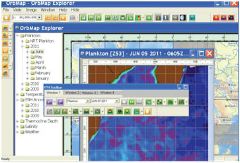 |
| OrbMap 7.5 software look and feel with new and improved icons and toolbars for easy navigation |
Improved Fish Catch Database: Offers captains a new tab to enter multiple species catch information and details, creating a historic database with helpful information on fishing ground conditions patterns and trends.
- Real-time Water Temperature Sensor Display: Instant access to sea water temperature on one screen with colour coded vessel tracking and graphics illustrating temperature changes; provides the ability to quickly identify temperature fronts.
- Enhanced Colour Bar Legend: Maps have a wider numeric scale representing colours, helping captains to clearly identify data value of each colour.
- New and Improved Icons and Toolbars for Easy Navigation: Navigate from map to map with one click via the new Fish Finding Maps window management tool. You can also obtain and visualize all conditions trends (currents, temperature, plankton, etc) with the multiple data animation tool.
- New Pop-up Alert Messages: Receive updates and communications From GeoEye directly in OrbMap, no more lost email messages.
- Link your fish catch database to your MasterCast tool and let MasterCast process information for you and highlight favourable fishing grounds.
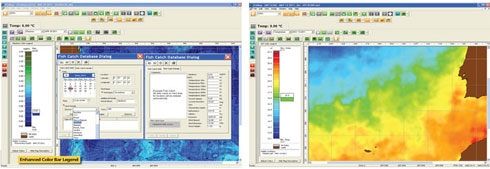 |
| Plankton base maps with thermocline depth contours showing fish catch databased with multiple species information and, sub surface temperature map showing new enhanced colour bar legend and real-time water tempaerature sensor display |
About GeoEye
Headquartered in Dulles, Virginia, GeoEye is a leading producer of satellite, aerial and geospatial information. The company is the premier provider of geospatial data, information and value-added products for the national security community, strategic partners, resellers and commercial customers.
GeoEye operates Earth imaging satellites, two mapping aircraft, possesses an international network of regional ground stations, a robust image archive, and advanced geospatial imagery processing capabilities.
The company was listed on Nasdaq in September 2006. GeoEye maintains a comprehensive Quality Management System (QMS) and has achieved corporate-wide ISO accreditation.
Source: GeoEye
Margaret E.L. Stacey
Editor Companies and Products
editorial@seafood.media
www.seafood.media
Information of the company:
|
Address:
|
2325 Dulles Corner Blvd.
|
|
City:
|
Herndon
|
|
State/ZIP:
|
Virginia (20171)
|
|
Country:
|
United States
|
|
Phone:
|
+1 703 480 7500
|
|
Fax:
|
+1 703 450 9570
|
|
E-Mail:
|
marineservices@geoeye.com
|
More about: 
|
|
|
|


 Print
Print